Discovering The Cape Raoul Track in Tasman National Park, Tasmania
If you’re a fan of hiking and looking for a great short walk in Tasmania, the Cape Raoul Track should definitely be on your list. Located in the Tasman National Park, with its beginning at the near Stormlea Rd, Cape Raoul is one of the 60 Great Short Walks in Tasmania.

Overview of Cape Raoul and why it’s one of Tasmania’s best short walks
Stretching for 14km, Cape Raoul’s 5-hour round trip return walk is a great way to spend a day in Tasmania’s wilderness. The trail is considered moderate to difficult, with steep sections and stunning views of the Tasman Sea and towering sea cliffs.
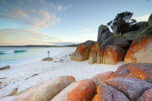
Along the way, you’ll pass through lush forests, vibrant wildflowers, and coastal heathland. Keep an eye out for local animals such as the Tasmanian devil, wedge-tailed eagles, and wallabies. Near the coast you may even get to see seals near the cliff edge!
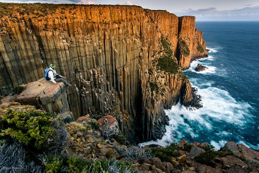
Cape Raoul’s highlights include the unique rock formations and views of the iconic dolerite cape columns known as ‘Candlestick.’
Tips for visitors and hikers to Cape Raoul
Before embarking on this walk, it’s important to plan for safety and prepare accordingly.
Always walk with company if possible, inform someone of your plans, and record your journey in log books.
Be equipped with a light backpack containing essentials like a weatherproof jacket, warm hat, sufficient water (1 litre per 3 hours per person), high-energy snacks, and a first-aid kit with an emergency space blanket.
Also, prepare for sunny conditions with a sunhat, sunglasses, and sunscreen, and consider insect repellent for added comfort. Remember to bring a rubbish bag for your trash.
If you have mobile phone reception, take your phone but use it sparingly, and in remote areas, pack extra food and an emergency shelter or tent.
Keep in mind that the trail can be steep and challenging, so hikers should be in good physical condition. Wear sturdy hiking boots and pack sunscreen, a hat, and insect repellent.
Dogs are not allowed in the Tasman National Park, and visitors should be respectful of the local flora and fauna.
Location and Accessibility
Location of Cape Raoul and how to get there
To get to the Cape Roaul Track, depart from Port Arthur on the B37, heading west for 8 kilometres. Then, make a left turn at the Highcroft and Stormlea signpost near Parsons Bay Creek. Continue for 9 kilometers on Stormlea Road, which is a dirt track, until you reach the car park. If you’re coming from Nubeena, you should turn right onto this road about 3 kilometers south of Nubeena.
Accessibility and entry fees
There’s no cost to access the trail, but visitors will need to purchase a National Parks Pass, which can be bought online or from various visitor centers across Tasmania.
Overall, Cape Raoul Walk is a wonderful and pleasant bushwalk with stunning views and incredible wildlife. It’s relatively accessible, but hikers should be aware of the challenges and come prepared with appropriate gear and supplies. If you’re in Tasmania and looking for a memorable day hike, Cape Raoul is definitely worth a visit.

Cape Raoul Trail Overview – What To Expect On This Walk
Overview of the Cape Raoul trail and its length
The Cape Raoul trail, situated at the terminus of Stormlea Road adjacent to the Raoul Bay Retreat, offers a convenient starting point with toilet facilities available for a small donation. The journey begins from the designated car park, leading hikers inland through a serene heathland. A notable feature early in the trail is a fallen log bridge spanning a small gully, representing the trail’s only natural water source.
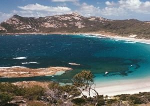
Upon progressing, hikers encounter a pivotal junction: the left path directs to Cape Raoul, while the right veers towards Shipstern Bluff. Opting for the left path, the landscape opens up, revealing the first of many breathtaking vistas of Tasman National Park’s iconic dolerite cliffs. Cape Raoul lies just beyond the east lower plateau. An alternate view to the right offers an impressive panorama overlooking Shipstern Bluff, extending to Bruny Island and the southern Tasmanian coast. This vantage point also exposes hikers to the area’s notorious intense winds, some of the strongest in Australia.
The trail then winds eastward along the cliff tops, descending steeply onto the Cape Raoul plateau. This transition marks a change in scenery to striking coastal banksia scrub. A mere 200 meters further, the northern coastline comes into view, showcasing landmarks such as Mt Brown, Arthurs Peak, and Mt Fortescue. To the east, the formidable 300-meter high cliffs of Cape Pillar near Tasman Island are visible.
Further exploration northeast leads to a trail fork. The right path continues to Cape Raoul, while the left offers a side trail with a closer look at the cliffs’ impressive scale. This spot also provides a chance to observe the seal colony at the base of Cape Raoul. The entire journey to the end of Cape Raoul spans 7 kilometers, making for a total 14-kilometer round trip. Allowing for breaks and moments of awe at the edge, a total of 5 hours is typically sufficient to complete this inspiring hike.
Difficulty level and recommended gear for hikers – Is Cape Raoul Hard?
The Cape Raoul trail is rated moderate to difficult, so hikers should be prepared for some steep sections and uneven terrain. Make sure to wear sturdy hiking boots and bring plenty of water and food. It’s also advisable to carry warm clothing, even in summer, as the weather can change very quickly in Tasmania. Don’t forget to bring sunscreen, a hat, and insect repellent as well.
While the hike is suitable for most people of average fitness levels, it’s always best to take things slow and enjoy the views along the way. You should always remember that conditions can change quickly in Tasmania and make sure to stay on the path at all times. There are no entry fees for the trail, but visitors will need to purchase a National Parks Pass before they can hike.
In summary, Cape Raoul is an amazing short walk that offers some of the best coastal scenery in Tasmania. It’s relatively accessible, but hikers should be aware of the challenges and come prepared with appropriate gear and supplies. If you’re looking for an unforgettable day hike in Tasmania, Cape Raoul is definitely worth considering.
The Cape Raoul Lookout – What To Expect
Description of the Cape Raoul Lookout and its significance
If you’re planning to hike the Cape Raoul Trail, then you definitely won’t want to miss the Cape Raoul Lookout. After a 2.2 kilometre lovely walk through a dry eucalypt woodland, you’ll finally reach the jaw-dropping lookout. This part of the trail provides stunning coastal scenery of Cape Raoul, the Tasman Peninsula, and Bruny Island. It’s the perfect spot to rest and soak in the scenery before continuing on your hike.
The Cape Raoul Lookout is an out-and-back trip, so you’ll have to retrace your steps back through the same forest scenery return hike once you’re done. However, the views are worth it, and the lookout provides an excellent opportunity to stop and admire the incredible coastal landscapes of Tasmania.
Spectacular views and photo opportunities
The Cape Raoul Lookout is renowned for its breathtaking views that provide ample photo opportunities. From the lookout, you have an unobstructed view of Cape Raoul and the Tasman Peninsula. The rugged coastline, dolerite columns and towering cliffs are a sight to behold, and the interplay of light and shadow creates a compelling visual effect.
Make sure to bring your camera or smartphone and capture the stunning views. Whether you’re a seasoned photographer or just an amateur, the Cape Raoul Lookout is a great hike with plenty of photo opportunities that you won’t want to miss. And don’t forget to take in the natural beauty of Tasmania with your own eyes too!
In conclusion, the Cape Raoul Lookout is a must-visit spot on the Cape Raoul Trail. It provides spectacular views of the coastline and offers a glimpse into the natural beauty of Tasmania. Make sure to bring appropriate gear and supplies for your hike and take your time to enjoy the journey. And when you finally reach the lookout, be sure to take a moment to marvel at the incredible scenery around you.
Cape Raoul – Part Of The Three Capes Track
Information about the Three Capes Walk
If you’re planning to take on the famous Three Capes Track in Tasmania, there are a few things you should know before you go. The walk is actually only two capes, with Cape Raoul being the third cape that is separate altogether. Nonetheless, it is an incredible hiking experience that offers breathtaking views of the Tasman Peninsula, Bruny Island, and the Tasman Sea.
The Three Capes Track is a 48-kilometre hike that takes an estimated 4 days to complete. It’s a challenging trek, and you should have a moderate level of fitness before tackling it. You will need to carry your own food, water, and camping equipment with you along the way. The campsites have toilets, but no showers are provided. The track is open from 1 October to 31 Mayseals each year, and booking is essential.
Hazards and Safety Tips For Walking Cape Raoul track
Hazards and risks associated with hiking at Cape Raoul
When hiking Cape Raoul track, there are several hazards and risks that you need to be aware of. These include:
-
- Weather conditions: Tasmania’s weather can be unpredictable, especially in the south eastern corner of Tasmania. The weather from Fortescue bay to eaglehawk neck changes quickly. During your hike, you may encounter strong winds, rain, or even snow. Make sure to check the weather forecast before setting out, and dress appropriately for the conditions.
-
- Cliffs: The Cape Raoul track runs along steep cliffs that drop into the sea. Be careful not to get too close to the edge, and don’t climb over any barriers or fences.
-
- Wildlife: Tasmania is home to a variety of wildlife, including snakes, spiders, seals, and Tasmanian devils. Keep an eye out for these creatures, and give them plenty of space.
-
- Getting lost: The Cape Raoul track is well-marked, but it’s still possible to get lost. Bring a map and compass, and make sure you know how to use them.
Tips for hikers to ensure their safety
To ensure your safety when hiking Cape Raoul track, follow these tips:
-
- Dress appropriately: Wear comfortable, sturdy footwear and bring warm, waterproof clothing. Take plenty of water and snacks to keep you hydrated and energized.
-
- Stay on the track: It’s essential to stay on the designated track to protect the fragile environment and minimize the risk of getting lost.
-
- Be prepared: Bring a first aid kit, torch or headlamp, and a charged phone or emergency beacon.
-
- Walk with a partner: Hiking with a partner or group is always safer than hiking alone. Make sure someone knows your route and expected return time.
-
- Follow park rules: Respect the park’s rules and regulations, and stay on designated tracks and campsites. Don’t light fires outside of designated fire places.
By following these safety tips, you can enjoy a safe and memorable adventure on the Cape Raoul track.
Flora and Fauna Near Cape Raoul
Overview of the flora and fauna on the Cape Raoul trail
The Cape Raoul trail offers walkers a chance to experience a stunning range of flora and fauna, unique to Tasmania’s rugged coastline. The trail winds its way through heathland and coastal scrub forests, which support an array of unique plant and animal species.
Unique animals and plants to look out for
One of the unique animals found along the Cape Raoul trail is the Tasmanian devil, known for its aggressive behavior and distinctive black colour. Other wildlife you may encounter include wallabies, echidnas, and a variety of bird species, such as the eastern spinebill and yellow-tailed black cockatoo.
The flora on the trail is equally impressive, with unique species such as the Tasmanian blue gum, white kunzea, and silver banksia. These species grow in the heathland and coastal scrub forests, providing a unique and diverse landscape.
However, it’s important to remember to respect the environment and avoid disturbing these rare species. Stay on the trail and follow park guidelines to help preserve this naturally beautiful landscape.
So, take your time on the Cape Raoul trail and soak up the natural beauty while keeping an eye out for these unique flora and fauna species. Enjoy the tranquility of being surrounded by such diverse vegetation and wildlife.
Accommodation and Facilities Near Cape Raoul
Accommodation and camping options near Cape Raoul
If you’re planning a visit to Cape Raoul, there are several accommodation options available nearby. The Storm Bay Bed and Breakfast and Harpers on the Beach are both within a 15 km radius of the trailhead, offering comfortable lodging options for travelers. Additionally, the NRMA Port Arthur Holiday Park is located only 12.79 km away, which is perfect for those who prefer camping or caravanning.
Facilities available for visitors
It’s important to note that facilities along the Cape Raoul trail are minimal, so visitors should plan accordingly. There are no paved roads leading to the trailhead and the trails themselves can be muddy at times. Be sure to wear appropriate footwear and bring extra clothing in case of inclement weather.
There are also limited facilities available for visitors once they reach the trailhead. However, there are toilet facilities and a small picnic area for visitors to use before they begin their walk.
As visitors move further along the trail, there are no other facilities available. Therefore, it’s important to bring enough food and water for the duration of the trip, as well as any other necessary supplies.
Remember to respect the environment and only take photographs, leave footprints and carry out what you bring in. Enjoy your Tasmanian wilderness experience!
Accommodation and Facilities Near Cape Raoul
Accommodation and camping options near Cape Raoul
If you are planning a visit to Cape Raoul, there are a few options for accommodation nearby. The Storm Bay Bed and Breakfast and Harpers on the Beach are both within a 15 km radius of the trailhead and offer comfortable lodging choices for visitors. In addition, the NRMA Port Arthur Holiday Park, located only 12.79 km away, is perfect for those who prefer camping or caravanning.
Facilities available for visitors
It’s vital to note that facilities along the Cape Raoul trail are minimal, so visitors should plan accordingly. To reach the trailhead, there are no paved roads, and the trails themselves can get muddy at times. Make sure you wear appropriate footwear and bring extra clothing in case of inclement weather.
At the trailhead, there are toilet facilities and a small picnic area for visitors to use before they begin their walk. However, there are no more facilities available along the route. Therefore, it’s essential to bring enough food and water for the duration of the trip, as well as any other necessary supplies.
Remember to respect the environment and only take photographs, leave footprints and carry out what you bring in. Enjoy your Tasmanian wilderness experience!
Conclusion
Summary of the Cape Raoul experience
Cape Raoul is one of the 60 Great Short Walks of Tasmania that offer the best of Tasmanias day walking opportunities. The trail spans 14 km and takes about 5 hours round trip. Cape Raoul is renowned for its breathtaking views, stunning coastal landscapes, and sheer cliffs.
Reasons why Cape Raoul is one of Tasmania’s best short walks
Cape Raoul’s rugged coastline offers hikers stunning views of the Tasman Peninsula’s exceptional landscape. The crystal-clear water, towering cliffs, and the diverse flora and fauna make the trek an unforgettable experience. The minimal facilities at the trailhead require visitors to come prepared, but the rewarding scenery more than makes up for the lack of amenities.
Cape Raoul Walk FAQ
1. What is the Cape Raoul Walk?
The Cape Raoul Walk is a captivating and often breathtaking journey located within the Tasman National Park in the south-eastern corner of Tasmania. This 14km return walk is known for its stunning views and diverse natural attractions, including the famous dolerite cliffs and Raoul Bay.
2. How long is the Cape Raoul Walk and what is its difficulty level?
The walk is a 14km return trip and is classified as a Grade 4 track. This indicates that it is a challenging walk, suitable for experienced hikers.
3. What can I expect at the beginning of the walk?
The walk starts as a pleasant bushwalk through beautiful heath, but it soon turns into a stunning adventure. You can expect a variety of terrains and scenic landscapes as you progress.
4. Are there any other walks or things to see around the Cape Raoul Walk?
Yes, the area also features several other tourist destinations and walks you may wish to visit, including Shipstern Bluff walk, Tasman Island cruise, Remarkable Cave, Crescent Bay, and Mount Brown walk. Each offers amazing and great views, contributing to this regions beauty.
5. What about wildlife viewing opportunities?
Keep an eye out for seals on the rocks and small islands below. The Seal Lookout point is a popular spot for observing these marine animals. The Wildlife Service Tasmania manages the area, ensuring the protection of the local fauna.
6. Is there any specific route direction for the Cape Raoul Walk?
The walk is often started from a junction that leads towards Port Arthur. It’s always wise to follow the designated paths for safety and environmental protection.
7. What phrase is often used to describe the Cape Raoul Walk?
“It’s never far” is a phrase commonly associated with the walk, emphasizing that despite its remote feel, it remains accessible and worth the journey.
8. What other nearby walks can be combined with the Cape Raoul Walk?
Nearby walks include the trek to Cape Hauy and the way out to Cape Raoul, both offering their unique landscapes and experiences.
9. Are there any facilities or services provided by the Wildlife Service Tasmania in the area?
The Wildlife Service Tasmania manages the area and provides essential services and information to ensure a safe and enjoyable experience for hikers.
10. What should hikers be prepared for on this walk?
Hikers should be prepared for variable weather conditions, carry adequate water and food, and wear appropriate hiking gear. The walk offers a mix of easy and challenging sections, so physical preparedness is key.
11. Can I visit Cape Raoul Walk all year round?
Yes, the Cape Raoul Walk is accessible year-round. However, weather conditions can vary, so it’s best to check the forecast and park conditions before planning your trip. We recommend visiting in the summer months for better weather conditions.
12. How do I get to the starting point of the Cape Raoul Walk?
The walk is located within the Tasman National Park, towards the south-eastern corner of Tasmania. It’s reachable by car, with the closest significant town being Port Arthur.